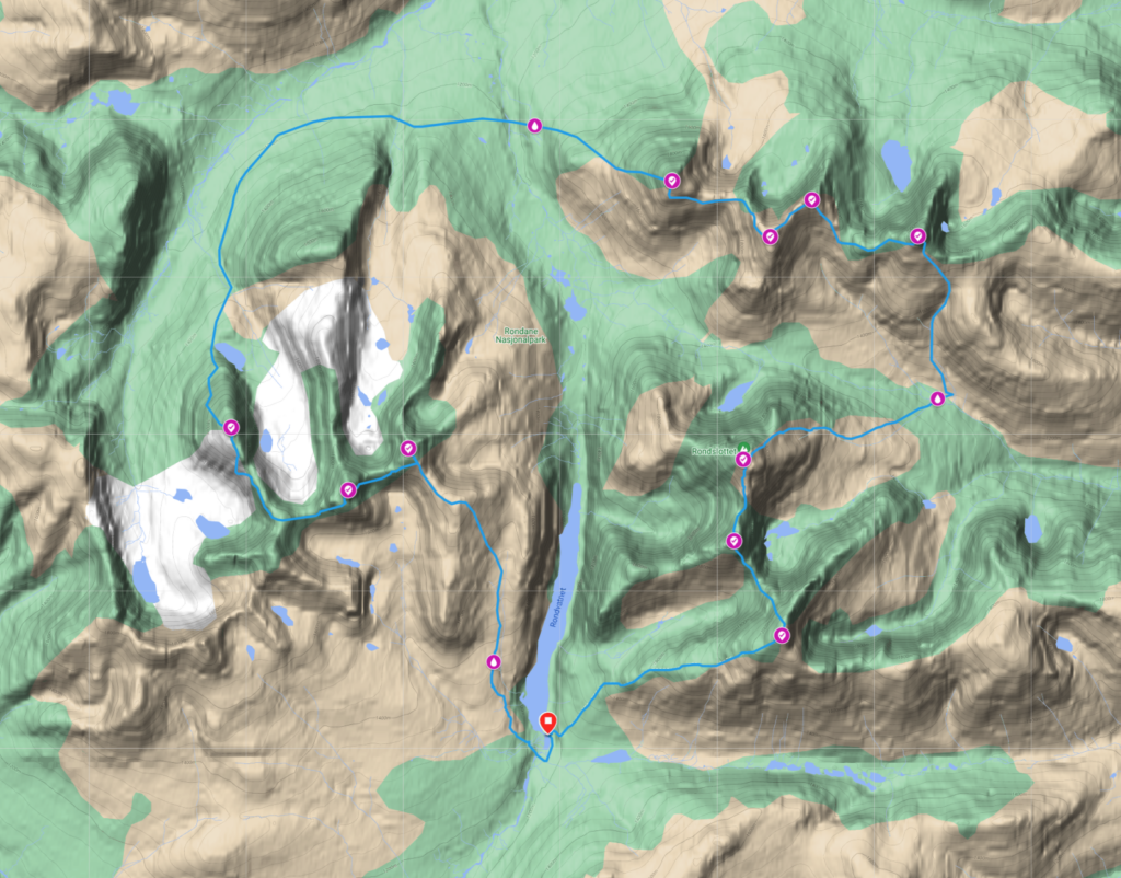
The legendary traverse with ten peaks above 2k around the national park with almost 5,000 meters to climb. The trail has been an adorable destination for the toughest in mountain running for decades. Its an distance of an marathon and the toughest race in the Nordic region. It is a rough ride where you are challenged mentally and physically in beautiful mountains.
Rules for the Rondane 2k classic
- Age for registration is 18 years.
- Participant shall not receive outside support along the way
- At the start and end, touch the door at Rondvassbu
- Touch the top cairn to all ten tops
- Detailed GPS tracks from the runner will be used as proof
In the competition, the participants will use gps tracking device in addition, intervals will be written at each support station at the mountain tops.
Details
| Date | Distance | Ascent | Descent | Start time | Time limits | Max starters |
|---|---|---|---|---|---|---|
| 07.07.2023 | 42,2 km | 4.700 m | 4.700 m | 06.00 Pm | 24 hours | 25 pax |
Download GPX
Veslesmeden at ut.no
The competition starts at Rondvassbu and runs clockwise with Veslesmeden as the first peak. Southwards from Rondvassbu and on a year-round bridge over Store Ula and past the path section to Smuksjøseter and Høvringen and up north of Jutulhogget so a gentle climb in light terrain towards Svarthammaren. Further uphill on Rondhalsen. Slightly north of Svarthammaren path sections to Dørålseter. From here to the northwest to the top. Further up to the top is easy ascent, but airy and very steep the very last stretch.
Storsmeden at ut.no
From Veslesmeden you probably complete the toughest and airiest parts west of Smedbandet to Storsmeden. Here there is a lot of loose rock, in places steep and some boulders that need to be split. There is also a rope to help you at the steepest point. The view both on the way up and up at the top (2016 masl) is majestic.
Trolltinden at ut.no
From Storsmeden down there is a cut that is often covered in snow. Should this be the case, be smart in your movements. After the gorge, you will cross a pyramid-shaped peak at 1890 masl, before the ascent which consists of giant steps with fairly solid rock – Stairway to heaven to 1897 masl. The route follows an animal trail down the west side of the mountain – the descent to hell. Lots of loose rock slide downhill when you run the steep gutters with rocks and snow. After a few minutes you reach a ridge that can be followed a few hundred meters south of the cairn on Trolltinden.
Digerronden, Midtrondene and Høgronden at ut.no
From Trolltinden, follow the ridge on the north side where there may be some snow on the rough path. Halfway down it slopes to the right in a rough and steep stone clock before you can again run on lighter terrain down towards and around Langholvatnet. Further over Døråldalen you pass the stream Langholsskridu and come to some damp bogs and a small river – Smedbekken.
Around Smedhamaren you follow the path up Digerronden from the west side. At Digerronden (2005 masl) you will be halfway in the route.
From Digerronden there is a path just over to Vestre Midtronden (2060 moh.) From Vestre Midtronden over to Østre Midtronden (2042 masl) takes place in rocks without a marked path. Stick to the edge to the north most of the way to Høgronden (2115 moh). Down from Høgronden, follow the path down a rocky slope. Then you come down to Midtbotn and .Vidjedalen where there are large lots with large specimens of Grønnvier.
Rondslottet, Vinjeronden at ut.no
Down from Høgronden you follow the path to the emergency cabin – Høgrondbue. At Høgrondbue, turn calmly to the right (south west) on the ridge beside or in the river channel towards Langglupdalen. You then cross Langglupdalen and start the last long climb which is up on an marked path all the way up to your highest peak on the route Rondslottet (2176 masl). You may meet snow on the way up and on the north side of the top.
From Rondslottet, go steeply down into a gorge and then go steeply up again and follow the edge between Storbotn and Styggebotn further up to Vinjeronden (2044 masl). The edge is nice to run on, but be careful on the edges. There is a lot of loose stone here.
Storronden at ut.no
From the top of Vinjeronden, follow the edge down to the band between Rondholet and Storbotn, deep in Rondholet. After that, go straight ahead and up to the last peak – Storronden. Here it is steep with a lot of loose rock. From Storronden, all that remains is to run down to Rondvassbu. On the way down you come past the path that leads to Vinjeronden and Rondslottet. After that point its easy running…